
Difference between revisions of "Information"
Jump to navigation
Jump to search
| (25 intermediate revisions by the same user not shown) | |||
| Line 18: | Line 18: | ||
! Village !! Latitude and Longitude !! Grid Reference | ! Village !! Latitude and Longitude !! Grid Reference | ||
|- | |- | ||
| − | | Carlton || 52. | + | | Carlton || 52.1510°N 00.3985°E || TL6453 |
|- | |- | ||
| − | | Carlton | + | | Carlton Hill || 52.1546°N 00.4011°E || |
|- | |- | ||
| − | | Willingham Green || 52. | + | | Carlton Green || 52.1384°N 00.3982°E || TL6451 |
| + | |- | ||
| + | | Willingham Green || 52.1598°N 00.3767°E || TL6254 | ||
|} | |} | ||
| + | |||
Online maps and aerial photography of Carlton-cum-Willingham is available through many services including [https://www.google.co.uk/maps/@52.1500528,0.3967806,2354m/data=!3m1!1e3 Google Maps], [http://www.bing.com/maps/?v=2&cp=52.154701~0.400320&lvl=15&sty=h&eo=0&q=Carlton%2C%20Cambridgeshire&form=LMLTCC Bing], etc. | Online maps and aerial photography of Carlton-cum-Willingham is available through many services including [https://www.google.co.uk/maps/@52.1500528,0.3967806,2354m/data=!3m1!1e3 Google Maps], [http://www.bing.com/maps/?v=2&cp=52.154701~0.400320&lvl=15&sty=h&eo=0&q=Carlton%2C%20Cambridgeshire&form=LMLTCC Bing], etc. | ||
| − | == | + | For other photographs see: |
| + | * [[Aerial Photos]] taken rather haphazardly in 2005 with a meteorological balloon and a digital camera. | ||
| + | * [[1949 Aerial Photographs]] taken by the RAF after the war. | ||
| + | * [[Panoramic Photographs]] stitched together with software | ||
| + | |||
| + | == Historic Maps == | ||
| − | + | There is a [[Historic Maps]] page. | |
| − | + | == Amenities == | |
| + | * Power supply - UK Power Networks supplies power to the village - [[105 mumber|call 105]] to report issues. | ||
== Houses == | == Houses == | ||
* Carlton Green | * Carlton Green | ||
** [[Finchley Gate Farm]] | ** [[Finchley Gate Farm]] | ||
| − | ** [[Woodman House]] | + | ** [[Woodman House|Woodman House (167)]] |
** [[Rood Hall]] | ** [[Rood Hall]] | ||
** [[Woodmans]] | ** [[Woodmans]] | ||
| − | ** [[Ginty's | + | ** [[169|169 (Ginty's)]] |
** [[170]] | ** [[170]] | ||
| − | ** [[ | + | ** [[Fields View Cottage|Fields View Cottage (171)]] |
| − | ** [[ | + | ** [[Apple Tree Cottage|Apple Tree Cottage (172)]] |
** [[Lopham's Hall]] | ** [[Lopham's Hall]] | ||
** [[Norney Farm]] | ** [[Norney Farm]] | ||
| Line 51: | Line 60: | ||
** [[Church Farm]] | ** [[Church Farm]] | ||
** [[South Barn]] | ** [[South Barn]] | ||
| − | ** [[ | + | ** [[Carl's Barn]] |
** [[St Peter's Church]] | ** [[St Peter's Church]] | ||
** [[War Memorial]] | ** [[War Memorial]] | ||
| Line 57: | Line 66: | ||
** [[Cocksedge Farm]] | ** [[Cocksedge Farm]] | ||
** [[Pond Cottage]] | ** [[Pond Cottage]] | ||
| − | ** [[Almancil]] | + | ** [[Almancil House]] |
| − | ** [[ | + | ** [[Long House]] |
** [[The Square House]] | ** [[The Square House]] | ||
| − | ** [[ | + | ** [[Church Barn]] |
| − | |||
** [[Field Cottage]] | ** [[Field Cottage]] | ||
** [[Madison House]] | ** [[Madison House]] | ||
| Line 86: | Line 94: | ||
** [[Crackers]] | ** [[Crackers]] | ||
** [[Woodland View]] | ** [[Woodland View]] | ||
| − | ** [[ | + | ** [[The Old Hall]] |
** [[Kingsfield]] | ** [[Kingsfield]] | ||
** [[Little Low Cottages]] | ** [[Little Low Cottages]] | ||
| − | ** [[Old Rose | + | ** [[The Old Rose & Crown]] |
| − | |||
** [[Boundary Cottage]] | ** [[Boundary Cottage]] | ||
* Carlton Hill - Acre Road | * Carlton Hill - Acre Road | ||
| Line 96: | Line 103: | ||
** [[Paverley]] | ** [[Paverley]] | ||
** [[Breydon]] | ** [[Breydon]] | ||
| + | ** [[Shantah]] | ||
| + | ** [[High House]] | ||
** [[Acre Cottage]] | ** [[Acre Cottage]] | ||
| − | ** [[Beech | + | ** [[Carlton House]] |
| + | ** [[Beech Lodge]] | ||
| + | ** [[1,2,3,4|1, 2, 3 & 4, Acre Road]] | ||
| + | ** [[1&2 Hall Farm Cottages]] | ||
| + | ** [[Hall Farm]] | ||
* Willingham Green | * Willingham Green | ||
| − | ** | + | ** [[Willingham House]] |
| + | ** [[Indiana]] | ||
| + | ** [[Gowing Autospares]] | ||
| + | ** [[The Bungalow]] | ||
| + | ** [[Raasay]] | ||
| + | ** [[Woolmer Cottage]] | ||
| + | ** [[1&2 Willingham Green Road]] | ||
| + | ** [[Lambra]] | ||
| + | ** [[Restormel]] | ||
| + | ** [[Stone Cottage]] | ||
| + | ** [[Christmas Cottage]] | ||
| + | ** [[Horseshoe Cottage]] | ||
| + | ** [[Cromwell Cottage]] | ||
| + | |||
| + | == Landmarks == | ||
| + | |||
| + | * [[War Memorial]] | ||
| + | * [[Millennium Walk]] | ||
| + | * [[Village Pump]] | ||
| + | * [[Phone Box]] | ||
| + | * [[Bus Shelter]] | ||
| + | * [[Post Box]] | ||
| + | * [[Raynor's Bridge]] | ||
| + | * [[Sipsey Bridge]] | ||
| + | * [[River Stour]] | ||
| + | * [[Green Lane]] | ||
| + | |||
| + | == Wildlife == | ||
| + | There is a page for the [[Carlton Wildlife|plants and animals]] of Carlton-cum-Willingham Green! | ||
== Test Pages == | == Test Pages == | ||
Used for testing only! | Used for testing only! | ||
| + | |||
| + | [[References to Follow]] | ||
| + | |||
| + | [[House Gallery]] | ||
[[TestSMW]] | [[TestSMW]] | ||
| + | [[Mapping Test]] | ||
[[Template:House]] | [[Template:House]] | ||
Latest revision as of 15:40, 7 September 2016
Location
Carlton-cum-Willingham Green lies within the eastern boundary of Cambridgeshire, although its postal address is Newmarket, Suffolk.
It lies in the triangle between Cambridge, Newmarket, and Haverhill, with the nearest neighbouring village being Brinkley.
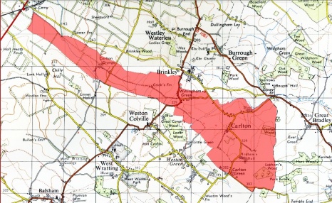
Carlton itself consists of three main parts, Carlton Green, Carlton, and Carlton Hill. The parish includes these parts plus Willingham Green.
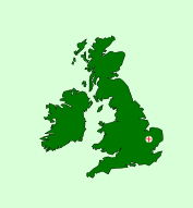
Location in the UK

Population Areas
Parish Boundary


| Village | Latitude and Longitude | Grid Reference |
|---|---|---|
| Carlton | 52.1510°N 00.3985°E | TL6453 |
| Carlton Hill | 52.1546°N 00.4011°E | |
| Carlton Green | 52.1384°N 00.3982°E | TL6451 |
| Willingham Green | 52.1598°N 00.3767°E | TL6254 |
Online maps and aerial photography of Carlton-cum-Willingham is available through many services including Google Maps, Bing, etc.
For other photographs see:
- Aerial Photos taken rather haphazardly in 2005 with a meteorological balloon and a digital camera.
- 1949 Aerial Photographs taken by the RAF after the war.
- Panoramic Photographs stitched together with software
Historic Maps
There is a Historic Maps page.
Amenities
- Power supply - UK Power Networks supplies power to the village - call 105 to report issues.
Houses
- Carlton Green
- Carlton
- Park Cottage
- Oakland
- Church Farm
- South Barn
- Carl's Barn
- St Peter's Church
- War Memorial
- The Old Rectory
- Cocksedge Farm
- Pond Cottage
- Almancil House
- Long House
- The Square House
- Church Barn
- Field Cottage
- Madison House
- Orchard House
- Walnut Trees
- Port-na-Craig
- Swedish Houses
- Odums
- Talland
- Cyrynti
- Hawkwind Stud
- The Old School House
- Carlton Hill - Brinkley Road
- Carlton Hill - Acre Road
- Willingham Green
Landmarks
- War Memorial
- Millennium Walk
- Village Pump
- Phone Box
- Bus Shelter
- Post Box
- Raynor's Bridge
- Sipsey Bridge
- River Stour
- Green Lane
Wildlife
There is a page for the plants and animals of Carlton-cum-Willingham Green!
Test Pages
Used for testing only!